

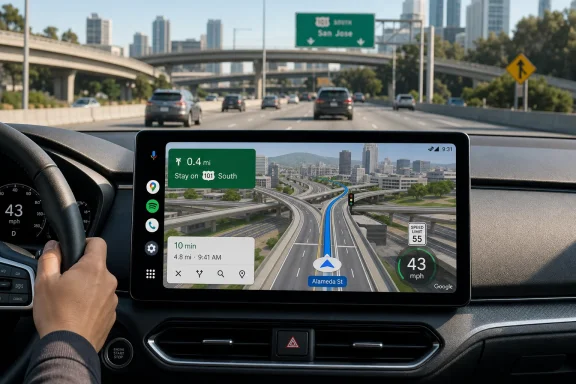
A more visual Google Maps experience reaches the car
For years, Google Maps driving mode has been built around a highly functional but deliberately restrained interface. The familiar flat map, route line, maneuver arrows, road labels, traffic colors, and occasional lane prompts have been designed for quick glances rather than visual drama.
Immersive Navigation changes that formula. Rather than treating the map as an abstract diagram of the road network, it presents the route as a more recognizable three-dimensional environment. Buildings, overpasses, terrain, road geometry, traffic signals, stop signs, crosswalks, and lanes can be rendered as part of the scene, creating a route view that is closer to what drivers encounter outside the windshield. Google
That does not make Android Auto a video game, nor should it. The point is practical context: helping drivers distinguish between a surface street, an elevated ramp, a parallel frontage road, or two exits that branch in rapid succession. At complex interchanges, especially, conventional flat maps can communicate the instruction correctly while still leaving the driver unsure about the physical shape of the maneuver.
Google has characterized Immersive Navigation as its most significant Google Maps driving update in more than a decade. The company says the updated view is intended to highlight important details such as buildings, overpasses, terrain, lanes, traffic lights, and stop signs, with the objective of making difficult turns and merges easier to interpret. Google
For Android Auto users, that promise is particularly relevant. A car display is often farther from the driver than a phone, subjected to more reflections, and viewed while the driver is processing road signs, mirrors, traffic, and vehicle motion. Better spatial clarity can matter more than extra visual polish.
What Google Maps Immersive Navigation actually adds
The name can sound like a broad branding exercise, but the visible changes are fairly concrete. Reports of the newer Google Maps interface describe a transition from the traditional largely grey navigation canvas to a 3D route environment with more detailed road and landmark rendering. AndroidPure
Buildings, terrain, and stacked roads
The clearest benefit comes from elevation. Traditional navigation maps need to use shadows, thin lines, labels, and directional arrows to explain where roads cross one another. That works well enough for ordinary intersections, but it is less effective when roads are layered.
An urban freeway interchange may include an elevated flyover, a service road, a tunnel entrance, multiple ramps, and an exit that curves below another road. A 3D presentation can convey those relationships immediately: one roadway is above, another continues underneath, and the desired ramp sits to the right at a separate level.
That is the strongest argument for Immersive Navigation. Three-dimensional context can reduce ambiguity, especially when a driver must make a quick decision in an unfamiliar area. Rather than asking the driver to mentally reconstruct road geometry from a flat schematic, Maps can show the geometry directly.
More specific road-level cues
The refreshed experience is not limited to buildings. Google’s description emphasizes navigation-relevant features including lanes, signals, and stop signs. Google
Those details have the potential to make a difference in several recurring navigation scenarios:
- Lane selection before a highway split
- Merging through multi-lane junctions
- Approaching a turn just after an intersection
- Identifying the correct branch of a forked road
- Navigating dense downtown corridors
- Understanding whether a route uses an elevated road or a parallel street
The value lies in reducing the gap between what the dashboard depicts and what the driver sees. Google Maps has long offered lane guidance in supported situations, but Immersive Navigation makes the route context richer around those instructions.
A better fit for modern vehicle displays
The timing also makes sense. Android Auto now appears on an enormous range of displays: conventional horizontal touchscreens, wide-format panels, portrait units, curved screens, and integrated cockpit displays. Google says Android Auto is compatible with more than 250 million cars on the road, a scale that makes dashboard interface changes consequential even when rollout is gradual. Google
A richer visual map can take better advantage of those displays, particularly the larger units found in newer vehicles. On a small screen, every extra element risks clutter. On a modern 12-inch or ultrawide dashboard display, however, terrain and road geometry can provide context without necessarily competing with route instructions.
That distinction matters. A navigation interface must never become visually busy simply because a vehicle has room for more pixels.
The Android Auto speedometer is the other important upgrade
The 3D redesign is the headline-grabbing feature, but the live speedometer in Google Maps for Android Auto may prove to be the more immediately useful change. It shows the vehicle’s current estimated speed within the Maps interface, separately from the speed-limit indicator that many users already know.
Google Maps has supported a speedometer on Android phones in regions where the associated feature is available. Google also cautions that the display is informational and that drivers should use the vehicle’s own speedometer to confirm their actual speed, because external factors can cause discrepancies. Google Maps Help
The key development is that the indicator is now appearing more broadly on Android Auto’s car display, where it has historically been conspicuous by its absence for many Google Maps users. Recent reporting indicates that the speedometer is appearing on installations outside the Google Maps and Android Auto beta tracks. 9to5Google
Speed limit versus live speed
It is worth separating two features that look related but serve different purposes:
- Speed-limit indicator: Shows the posted or mapped speed limit for the current road, where Maps supports it.
- Live speedometer: Shows Google Maps’ estimate of how fast the vehicle is currently moving.
Drivers may have seen the first without the second for years. That created an awkward mismatch: Google Maps could display the road’s stated limit but not show the vehicle’s measured pace on the same screen.
The newer Android Auto capability brings the live speed readout alongside the speed-limit information, giving the display a more complete at-a-glance driving-status role. AndroidPure reports that users should look for the live speed readout near the speed-limit sign; if only the limit is present, the server-side feature may not yet be enabled on that account or device. AndroidPure
Why drivers have wanted this for so long
The usefulness is straightforward. With the current speed and detected speed limit visible in one place, a driver can reduce the need to shift attention between the instrument cluster and the infotainment screen.
That should not be overstated. The car’s own instruments remain the primary authority for speed, and a navigation app cannot replace a vehicle speedometer. Google explicitly says as much in its support documentation. Google Maps Help
Still, the dashboard map can act as a convenient secondary reference. On routes with frequent limit changes—suburban arterials, construction zones, highway transitions, or unfamiliar city streets—that secondary context may make Google Maps feel more complete.
The update also reduces a longstanding feature disparity within Google’s own mapping ecosystem. Google Maps on a phone can offer a speedometer in supported regions, while Android Auto users have often had to rely on their vehicle display, Waze, or another navigation app for a comparable on-screen reading.
This is a server-side rollout, not a conventional app update
The most important practical detail is also the least glamorous: installing an app update does not guarantee either feature will appear.
Reports from 9to5Google and AndroidPure describe Immersive Navigation and the Android Auto speedometer as server-side changes. In plain English, Google can enable the experience remotely for selected accounts, regions, devices, or combinations of software and hardware without pushing a separate public app version through the Play Store. 9to5Google AndroidPure
That deployment model is common across Google services. It lets the company test capacity, rendering behavior, usability, compatibility, and regional requirements before making a change universal. It also means two drivers with the same phone, the same car, and the same version of Google Maps can see different interfaces.
Why Google uses staged feature flags
A gradual rollout has obvious benefits for a navigation feature of this scale:
- Reliability testing: Google can observe whether 3D rendering behaves consistently across a wide range of phones and vehicle displays.
- Performance management: Detailed graphics may place greater demands on devices, particularly during long trips, hot-weather driving, or wireless Android Auto sessions.
- Regional validation: Maps data quality and road-sign coverage vary by country, city, and road type.
- Safety feedback: A visually richer UI must be tested carefully to ensure that it improves comprehension rather than adding distraction.
- Rapid correction: If a problem emerges, Google can pause, adjust, or narrow availability without waiting for every user to update an app.
The downside is predictably frustrating. Users can update Maps, update Android Auto, reboot the phone, clear caches, reconnect the vehicle, and still see nothing change. When a feature is governed by a remote flag, local troubleshooting has limited power.
Do not mistake beta access for universal access
Earlier sightings suggested that the Android Auto speedometer was concentrated among beta users. The current reports are more encouraging because they place the feature on stable builds as well. 9to5Google
But “stable” does not mean “available to everyone.” It means beta enrollment is no longer the only route through which people are seeing it.
This is an important distinction for users tempted to join beta channels solely to get new dashboard features. Beta software can introduce instability, unusual battery behavior, compatibility problems, or regressions—costs that are especially unwelcome in a car environment. A server-side rollout that reaches stable users is a better outcome, even if patience is still required.
Availability remains broadening, not complete
Google introduced Immersive Navigation as a U.S.-first rollout, saying availability would expand over the following months to eligible Android and iOS devices, CarPlay, Android Auto, and vehicles with Google built-in. Google
The wording matters. Google did not promise that every Android Auto installation, every car display, or every country would receive the feature on the same day. It framed expansion around eligible devices and platforms.
Recent user reports indicate that availability is increasing, but it is still not universal. A 9to5Google reader poll earlier in July found that only a little over 10% of respondents had received Immersive Navigation at that time. 9to5Google
That figure should not be treated as a scientific global adoption measurement. Reader polls are self-selecting, and the respondents are more likely than average to track Google Maps and Android Auto changes closely. Nevertheless, it captures the basic reality: the feature was still scarce shortly before this broader wave of sightings.
Geography, hardware, and account state may all matter
The rollout appears to involve more than one variable. 9to5Google notes that region and possibly device type can affect when Immersive Navigation becomes available. 9to5Google
That is plausible for several reasons. A 3D navigation view depends on mapping data, display characteristics, device rendering performance, and Google’s support matrix. The speedometer can be constrained by regional speed-limit data, local policy considerations, or different Android Auto configurations.
The most sensible expectation is therefore not that every driver will receive both changes simultaneously. Some may get Immersive Navigation first, while others see the speedometer first. Some may receive both only after a later server-side expansion.
How to tell whether the features have arrived
There is no single Android Auto setting labelled “Enable Immersive Navigation.” The absence of a toggle is not an oversight; it is a consequence of the gradual remote rollout.
A practical check is still worthwhile, particularly after confirming that both Google Maps and Android Auto are up to date.
Check Google Maps and Android Auto in this order
- Update Google Maps from the Play Store. This does not force the remote feature flag, but it ensures an outdated client is not the obvious blocker.
- Update Android Auto. Some Android Auto components may be installed as system software depending on the phone, but the Play Store remains the appropriate place to check for an available update.
- Open Google Maps on the phone. Reports indicate that the Gemini icon replacing the older Assistant icon in the upper-right area can be a visible sign that the updated Maps experience has reached the account. 9to5Google
- Begin a route through Android Auto. Look at the navigation canvas itself rather than hunting for a menu item. Detailed 3D buildings, terrain, rendered overpasses, and richer lane-level context are the more meaningful tells. AndroidPure
- Check the speed panel. If a live speed reading appears alongside the speed-limit sign, the Android Auto speedometer feature is active. If the screen only shows the posted limit, the speedometer may not have reached that configuration yet. AndroidPure
What not to do
There is little evidence that cache clearing, reinstalling Maps, repeatedly disconnecting Android Auto, or enrolling in a beta program will reliably force a server-side feature to arrive. Those actions can solve ordinary application problems, but they cannot compel Google’s servers to assign an account to a staged experiment or deployment group.
It is also wise not to treat the feature as a reason to use a phone while driving. Android Auto exists to make navigation, messaging, media, and calls more manageable through a car-oriented interface. Google’s Android Auto guidance emphasizes voice-guided navigation, live traffic, lane guidance, and interaction patterns intended for in-car use. Google Android Auto Help
The strengths of Immersive Navigation on Android Auto
Google’s update has several genuine advantages beyond aesthetics.
It can improve route comprehension
The clearest benefit is visual explanation. Many navigation mistakes happen not because the route instruction was technically wrong, but because a driver misread how it related to the road ahead. A 3D interchange view can make an exit, overpass, or lane transition easier to recognize.
It makes high-resolution displays more useful
Car displays have become larger, sharper, and more central to the driving experience. A richer maps interface uses that additional real estate to add environmental context rather than merely enlarging labels and route lines.
It narrows the feature gap between platforms
Google positioned Immersive Navigation for phones, Android Auto, CarPlay, and cars with Google built-in, instead of reserving it for a single premium automotive platform. Google
That is significant because Android Auto remains the way many drivers access advanced navigation in vehicles that do not have Google’s software embedded in the dashboard. The new experience helps reduce the sense that phone-projection systems are permanently second-class.
The speedometer addresses a practical omission
The live speed display is a small feature with a large usability payoff. It complements, rather than replaces, the car’s instrument cluster and makes Google Maps more competitive with navigation alternatives that already offer both current speed and speed-limit information.
The risks: visual richness must not become visual overload
There are also valid reasons to evaluate the change cautiously.
The first is distraction. A navigation map is not a decorative screen saver. More building geometry, more textures, more road detail, and more visual motion can be helpful only if they improve decision-making at a glance.
Google’s best-case scenario is a map that makes a difficult interchange easier to understand before the driver reaches it. The worst-case scenario is a visually impressive display that draws attention away from the road. The ultimate quality of Immersive Navigation will depend less on how sophisticated it looks and more on whether its visual hierarchy consistently puts the next driving decision first.
The second risk is performance. Android Auto operates across a broad hardware ecosystem, including older phones, wireless adapters, heat-prone cabins, and head units with uneven display quality. A more detailed 3D environment could expose weaknesses in responsiveness or device thermal management, even if Google has designed the feature with broad compatibility in mind.
The third is false precision. A richly rendered digital scene can feel authoritative, but it remains an interpretation of map data, location signals, and road information. Construction, new lane markings, temporary barriers, detours, and altered traffic patterns can outpace any map service. Drivers must continue to prioritize posted signs, lane markings, traffic control devices, and conditions on the road.
That point is especially important for the speedometer. Google says the Maps speed display is informational and may differ from the vehicle’s actual speed because of external factors. Google Maps Help The dashboard instrument cluster and applicable road rules remain the reference point.
A meaningful Android Auto upgrade, even before everyone receives it
Immersive Navigation and the Android Auto speedometer are different kinds of improvements, but they share an important goal: make Google Maps more useful during the moments when driving navigation is hardest.
The 3D map view seeks to make confusing road geometry easier to grasp. The speedometer adds a small but practical piece of information that many drivers have wanted directly on the car display. Together, they signal that Google is treating Android Auto navigation as more than a scaled-up phone map.
The rollout’s server-side nature will continue to test users’ patience. Not every Android Auto driver will see the new interface immediately, and neither a clean installation nor beta enrollment should be considered a reliable shortcut. Yet the reports of availability on stable builds are the relevant milestone: these capabilities are moving beyond a narrow testing audience. 9to5Google
For Windows users who depend on Android phones as the center of their connected-car setup, that is the bigger story. Google Maps on Android Auto is becoming more visually capable, more context-aware, and more complete as an in-car navigation tool—provided Google keeps the experience fast, restrained, and focused on the road ahead.
Update: Reports point to a new 3D toggle and Gemini-enhanced guidance (July 26, 2026)
Autoevolution reports that some newly enabled users are seeing a dedicated 3D control in Google Maps’ navigation settings, under Map Display, to turn on the richer route view. That would be a more direct activation path than earlier reports suggested, though availability still appears tied to Google’s staged server-side rollout.
The outlet also says the updated experience may add clearer lane highlighting, smart zoom behavior near turns, transparent building rendering, and expanded Gemini voice guidance. It further reports more detailed alternate-route comparisons, including potential tolls, disruptions, and ETA tradeoffs.
These features are reportedly reaching eligible U.S. users across Android Auto and CarPlay as well as phone navigation, while other regions remain largely excluded for now.