

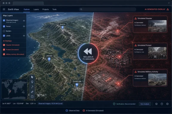
Google’s July 30 launch post described Nano Banana as a way to visualize historical sites, build location-specific infographics, mock up real-estate projects and imagine future development. Its July 31 update now says the company is withdrawing the feature while it develops “stronger guardrails,” after screenshots of generated imagery appeared to violate its policies. The feature was available only in Google Earth on the web; it was not a change to the legacy Windows Google Earth Pro desktop application.
The swift reversal confirms the core problem was not whether users could create a fanciful rendering of an empty lot. It was that Google put a high-quality image editor directly inside a trusted geospatial viewer, supplying the location, viewpoint, visual context and a familiar Google Earth frame in one workflow.
Google Earth’s launch promise collided with its evidentiary role
Google’s product announcement framed the integration as an imaginative design and education tool. It suggested rendering Pompeii before Vesuvius erupted, turning a site into an infographic, placing a proposed lakefront house on a real plot, or reimagining an urban lot as a commercial district. Those are recognizable uses for planning presentations and classroom discussion, provided the output is unmistakably presented as a simulation.
But the same mechanism could alter a location into an apparent scene of violence, a crowd gathering, a strike crater or a sensitive installation. 404 Media reported that researcher Henk van Ess used the feature to place refugees near the U.S.-Mexico border, add a nuclear facility in Iran and stage a fatal crash on a street in Amsterdam. Other outlets and independent testers reproduced the basic concern: prompts could add plausible-looking events to Google Earth’s real-world imagery without requiring a user to first export an image, open another AI service and then composite the result manually.
That difference is more than convenience. A malicious user can already edit a screenshot from almost any mapping service with a generative-image tool. Google Earth’s integration reduced the process to a search, a prompt and a screenshot, while preserving the visual grammar that makes the result seem more credible: the map perspective, place labels, terrain and Google Earth’s own interface.
For open-source intelligence analysts, journalists and incident-response teams, this is a practical threat model rather than a theoretical argument about “AI misinformation.” Google Earth is frequently used to identify landmarks, compare imagery over time and assess reports from places that are inaccessible or contested. Once an image is separated from the service and shared in a group chat, an X post or a news tip, viewers may reasonably recognize the Google Earth interface but have no immediate way to tell whether the scene was observed or generated.
The important distinction is that Google says Nano Banana output did not alter the public, shared Google Earth view for other users. The underlying imagery was not silently rewritten. Yet that limitation protects Google Earth’s central database, not the downstream screenshots most likely to travel without context.
The watermark answer did not address the sharing problem
Before the rollback, Google said every Nano Banana image created in Google Earth carried a SynthID digital watermark. The company also directed users who were unsure about an image to Gemini or Google Lens and said it blocked image creation involving harmful topics.
Those controls may be useful in a controlled workflow, especially where the original generated file is retained and a recipient knows to run a provenance check. They did not address the failure demonstrated in public: images circulated as screenshots in a trusted mapping environment, often to audiences who had no reason to expect an AI-generated scene in Google Earth at all.
A watermark is an after-the-fact verification mechanism. It puts the onus on the person encountering an alarming image to suspect it, preserve enough of the original material for analysis and use the relevant Google tools. In a fast-moving incident — a claimed missile strike, border event, industrial fire or protest — that is the opposite of how many images spread. The emotional claim comes first; verification arrives later, if at all.
PC Gamer reported that it was able to create a fabricated war-zone-style image of a hometown despite Google’s assertion that it prevented harmful prompts. 404 Media’s reported examples, along with reporting from The Atlantic, showed that the tool was not limited to benign concepts such as gardens or historical reconstructions. Google’s policy controls may have blocked some requests, but the examples that got through demonstrate a more fundamental problem: the categories of misleading location-based imagery are too broad and contextual for a basic harmful-topic filter to solve.
The company’s own launch material also stressed Nano Banana 2’s “advanced world knowledge,” real-time web-search grounding, precise instruction following and photorealistic output. Those are useful capabilities for ordinary image production. In Google Earth, they increase the likelihood that an invented element can fit the geography, architecture and visual expectations of a particular place.
“Rolling back” leaves the most important implementation questions unanswered
Google’s language is significant. It said it was “rolling back” the feature while implementing stronger guardrails, not permanently canceling the integration. The original launch article remains published, now carrying the rollback update at its top. As of August 9, Google has not announced a return date, described the new safeguards, or explained whether independent open-source-intelligence and misinformation researchers will test a revised version before release.
That leaves several material questions unanswered:
- Google has not said whether any generated images remain accessible to the users who created them, or whether the rollback simply removed the creation interface.
- Google has not defined whether future controls will block certain subjects, certain real-world locations, certain categories of edits, or the ability to generate photorealistic imagery against a Google Earth view altogether.
- Google has not said how it will distinguish a legitimate urban-planning concept from a synthetic disaster, military deployment or politically inflammatory crowd scene at the same location.
- Google has not committed to a visible, persistent in-product treatment that would survive ordinary screenshots and make a generated scene difficult to confuse with observed imagery.
The last point is the one that will determine whether a relaunch is credible. Blocking a list of dangerous terms is a weaker response than separating evidence from simulation at the product-design level. A tool intended for planning, historical imagination or architectural visualization could live in a clearly delineated concept mode, with conspicuous framing that it is not satellite or aerial observation. A tool that lets generated pixels inhabit the normal Earth viewing experience inherits the trust users have built around that experience.
Google will also have to account for the fact that harmful content is not limited to graphic violence. A fictitious homeless encampment, a false crowd outside a company building, an invented construction project, apparent storm damage or a purported immigration event can all be used to mislead without triggering an obvious keyword-based safety rule. The credibility risk lies in the claimed location and timing, not merely in the object added to the scene.
Windows users are being pushed toward the web version where this happened
For Windows users, the episode lands amid Google’s broader move away from Google Earth Pro as the place where new Earth features arrive. Google announced in July that new downloads of Google Earth Pro will end on June 25, 2027, though existing installations will continue to work after that date. The company is steering users toward the web and mobile versions for current functionality, including its expanding set of AI-powered capabilities.
Nano Banana’s brief availability reinforces what that transition means in practice. Google Earth Pro remains a useful desktop tool for local KML and KMZ workflows, saved places and established Windows-based routines, but Google’s product strategy is putting new features into the browser first. The image-generation test did not touch Google Earth Pro, but it showed that future web-only changes can affect the trust model of the service as much as its feature list.
That should matter to organizations that use Google Earth as part of a verification workflow. A report, training guide or internal procedure that treats a Google Earth screenshot as presumptively observational evidence now needs an explicit provenance step: record the source, preserve the original link or project context where possible, compare against independent imagery, and do not rely solely on a familiar interface as proof that the depicted event occurred.
Google’s retreat was the right immediate move. Its original product framing treated a map as a canvas; users promptly demonstrated that, in the real world, a map is also evidence. Until Google can enforce a durable boundary between those two roles, keeping generative image creation out of the normal Google Earth experience is the safer result.