

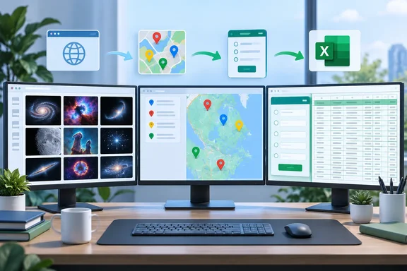
Each project moves data in a different direction. Below are the steps and the limits that matter before you start.
Project 1: Build a NASA picture gallery with Power Query
NASA's Astronomy Picture of the Day (APOD) is a good fit because each entry already carries a date, title, explanation, credit, page URL and direct image URL. Power Query can load those fields into a table, and the IMAGE function can render the pictures in cells.
Steps
- In a blank workbook, open the Data tab and choose From Web.
- Paste NASA's WordPress-based endpoint:
[url]https://science.nasa.gov/wp-json/wp/v2/apod-basic/?api_key=DEMO_KEY[/url]. Click OK. - When Power Query shows a list of records, choose To Table on the Transform tab. Accept the defaults if a dialog appears.
- Expand the records. Keep
date,titleandhdurl. Keepurlif you want a link to the NASA page. Also keepexplanationif you want the description text, since the NASA response uses that field name. - On the Home tab, click the top half of the split Close & Load button.
- Add a column called Image. In its first cell, enter
=IMAGE(and select thehdurlcell. Close the parenthesis and press Enter. In a table this typically appears as a structured reference such as=IMAGE([@hdurl]). - If Excel shows two security prompts, the walkthrough says to choose Paste everything in the first and Enable in the second.
- Resize the column and rows, then use Data > Refresh All to update.
On refresh timing, Microsoft's documentation says you can set a connection to refresh when the file opens. That is done through the Connection Properties dialog, on the Usage tab. Microsoft also notes that Power Query caches external data locally and doesn't refresh that cache automatically.
What the project doesn't do by default
The bare URL returns the current APOD entry. It won't build a growing archive of past pictures. For a multi-day gallery you need a date range. NASA's APOD API supports start_date and end_date, and a count option for random entries. Per third-party API documentation, date, count and start_date/end_date are mutually exclusive, so pick one approach per query. That documentation describes the older api.nasa.gov service. NASA's own notes say the legacy service is due to go offline December 1, 2026, which is why the newer endpoint matters. Test the parameters against the new endpoint before you rely on them.
Not every APOD entry is a still image. NASA lists a media_type field, and IMAGE needs a direct image-file URL. A sturdier build filters on media_type so a video entry doesn't produce an error cell.
The IMAGE function's rules
Microsoft's documentation sets the boundaries:
- The source must be an HTTPS URL to a supported format: BMP, JPG/JPEG, GIF, TIFF, PNG, ICO or WEBP. WEBP isn't supported on the web or Android.
- A URL that needs authentication won't render. A redirected URL is blocked for security reasons.
#BLOCKED!points to security settings on external content.#CONNECT!points to a network or server problem.#VALUE!points to an unsupported format or bad arguments.- URLs are limited to 255 characters. Microsoft's workaround is to paste the image link into a cell and reference that cell.
- Add alt text as the second argument for accessibility.
Keeping column widths steady
The walkthrough suggests a fix if refreshes keep resetting your layout. Select a cell in the table and go to Table Design > Properties. In External Data Properties, clear Adjust column width. I couldn't confirm that exact label against Microsoft's documentation, so treat it as a tip to check in your own build.
A note on trust
Microsoft's refresh guidance warns that external data may be disabled by default, and that you should trust connection sources before enabling them. A workbook that calls a public NASA endpoint is low-risk. Apply the same habit to any workbook you receive that is wired to outside sources.
Project 2: Turn an Excel list into a Google My Maps map
This is the one project where data leaves Excel for a non-Microsoft service. Google My Maps turns spreadsheet rows into clickable markers you can style, add photos to, split into layers and share.
Preparation
- Use one location per row. Add a header row with clear titles such as Name, Address, City, State and Country.
- Google's help page lists XLSX among supported formats, alongside CSV, TSV, KML, KMZ, GPX and Google Sheets.
- The first row should hold titles. You also need a column with latitude and longitude, addresses, place names or WKT geometry.
- Google says not to import files with more than 2,000 rows. Non-KML files can be up to 40 MB.
Import steps
- Save the workbook as
.xlsx. - Sign in to My Maps and open or create a map.
- In the legend, click Add layer, name it, then click Import under the new layer.
- Upload the file and click Select.
- Pick the columns that hold the location data, such as Address, City, State and Country, and click Continue.
- Pick the column to use as marker names, then click Finish.
You can import a second workbook as another layer on the same map. A sensible habit is to scan the result for markers that landed in the wrong place. Incomplete or ambiguous addresses are the usual suspects. That's a practical caution, not a documented failure mode.
Updating the map later
The walkthrough says edits to the original workbook don't flow through automatically, and you have to reimport. That matches Google's documentation. The finer detail is that Google's reimport options are described for Google Sheets and CSV files. Those options are Replace all items, Update matching items, Add more items and Merge matching items. With Update matching items, you choose a matching column. Matching features keep their styles and media. Unmatched old features are deleted.
XLSX isn't listed in those reimport workflows. If you expect to update the map repeatedly, consider keeping the master list as a Google Sheet or CSV. That's my inference from the documentation, not a tested workflow.
Project 3: Let Microsoft Forms fill a workbook
The third project works the other way round. Other people supply the data. You create a form in Microsoft Forms, share it, and analyze the answers in Excel. Polls, quizzes and votes are the obvious uses.
Steps
- Create a new form and add your questions: choice, text, rating or whatever suits.
- Click Collect responses and share the form.
- Once answers arrive, open the responses view. Microsoft's current help refers to the View responses tab.
- Select Open in Excel. The workbook opens in Excel for the web.
- Sort, filter, summarize or chart the data.
Where the workbook lives, and how "live" it is
Microsoft says the workbook is stored in OneDrive or SharePoint Online, depending on where the form started. A personal form creates a workbook in OneDrive for work or school. A group form creates it in SharePoint Online.
Microsoft's wording on updates is more cautious than "instant." For forms created on the web, response data syncs with the workbook. You see the latest updates each time you click Open in Excel or reopen the workbook.
A separate Microsoft page describes live data connections for forms created in OneDrive for work or school, SharePoint Online, Excel for the web, Teams or the Forms web part. It also covers Microsoft 365 group forms and forms with a Power Automate workflow. Expect to refresh or reopen unless you're in one of those cases.
Your own annotations, formulas and functions in the workbook sync as well, according to Microsoft. That makes it a decent scratchpad for the results. One benefit of this project is that you don't need to design the sheet first. The form defines the columns for you.
Quick comparison
| Project | Data direction | Main limit |
|---|---|---|
| NASA APOD gallery | Web to Excel | Default query returns only the current entry. Needs HTTPS image URLs and filtering of non-image entries. |
| Google My Maps | Excel to web | 2,000-row ceiling. XLSX isn't listed in the reimport and merge options. |
| Microsoft Forms | People to Excel | Update behavior depends on where the form was created. Often you refresh or reopen. |
Verdict
These are small projects, but they show three useful ideas in Excel. One is pulling structured web data through Power Query. Another is handing data to a mapping tool. The third is collecting input from other people. All three carry fine print: the NASA query returns one entry, the map can't live-sync an XLSX, and the form workbook updates when you reopen it. Knowing that up front saves you an afternoon of confusion.
The original piece closes with a teaser about linking Excel to a PC folder so a weekly report updates itself. That isn't one of the three projects, so I haven't covered it here.
References
- Take Excel beyond the spreadsheet with these 3 unusual weekend projects (Oct. 2–4) How-To Geek · 2026-10-02T11:00:14+00:00
- Import map features from a file - Computer - My Maps Help support.google.com
- Refresh an external data connection in Excel | Microsoft Support support.microsoft.com